|
Sorano
|
|
|---|---|
| Comune di Sorano | |
 |
|
|
Coat of arms
|
|
|
Location of Sorano
|
|
|
Sorano
Location of Sorano in Italy
|
|
| Coordinates: 42°40′55″N 11°42′54″ECoordinates: 42°40′55″N 11°42′54″E | |
| Country | Italy |
| Region | Tuscany |
| Province | Grosseto (GR) |
| Frazioni | Castell’Ottieri, Cerreto, Elmo, Montebuono, Montevitozzo, Montorio, San Giovanni delle Contee, San Quirico, San Valentino, Sovana |
| Government | |
| • Mayor | Pierandrea Vanni |
| Area | |
| • Total | 174.56 km2 (67.40 sq mi) |
| Elevation | 379 m (1,243 ft) |
| Population
(1 January 2022)[2]
|
|
| • Total | 3,091 |
| • Density | 18/km2 (46/sq mi) |
| Demonym(s) | Soranesi |
| Time zone | UTC+1 (CET) |
| • Summer (DST) | UTC+2 (CEST) |
| Postal code |
58043
|
| Patron saint | St. Nicholas |
| Saint day | December 6 |
| Website | Official website |


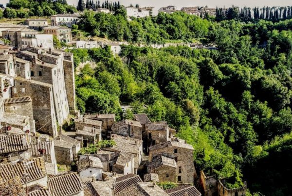
Sorano is a town and comune in the province of Grosseto, southern Tuscany (Italy).
It as an ancient medieval hill town hanging from a tuff stone over the Lente River.

Disappearing from history under the Roman domination, it is again known in 862 when a county was founded by Emperor Louis II, under the Aldobrandeschi suzerainty. The Aldobrandeschi were the most powerful feudataries of southern Tuscany for more than four centuries, disappearing in 1312 when Margherita, son of Ildibrandino, died without male heirs. His daughter Adelaide married to Romano di Gentile Orsini, who added the city to the family fiefs.
The county of Pitigliano-Sorano fought against the Republic of Siena, but was forced to accept its suzerainty from 1417. It regained a full independence in 1556, when the latter was annexed to the Duchy of Tuscany. The fortress, due to its strategic position, was frequently attacked; it was also the seat of fratricidal fights between the Orsini. In 1604, with the death of Alessandro di Bertoldo, it became part of the Grand Duchy of Tuscany.
It became part of the Kingdom of Italy in 1860.